Download a property boundary as a DXF, KML or GeoJSON file
On this page
Redrawing a lot from a screenshot is slow and easy to get wrong. MapMyLot gives you the lot's boundary as a file you can open in CAD, Google Earth or a GIS, drawn from the same government cadastre record as the map and the report, with the length of every side.
Who can download the files
Boundary files come with MapMyLot Pro, for any lot where they are offered, and with the report for a lot: buy a lot's report and that lot's files are included. There is nothing extra to pay, and downloading a file doesn't use a lookup.
If you bought a report without signing in, you can download that lot's files in the browser you bought it in.
Where to find them
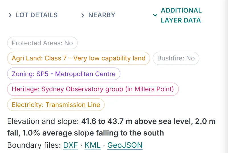
- On the map. Open the lot and go to the Additional Layer Data tab. Under the layer chips is Boundary files: DXF, KML, GeoJSON. Click a format to download it. Without Pro or the lot's report the line shows a lock.
- When your report is ready. The Your report is ready panel has the same three links.
Files are named after the jurisdiction and lot, for example mapmylot-qld-<lot id>.dxf.
Find the lot and download its boundary
Open the mapBoundary files come with Pro or the report for a lot. Visitors get 5 free lookups a day.
What is in each file
Every file carries the lot ID and jurisdiction, the area and perimeter, the length of every side, the cadastre source's attribution and licence, and a note that it is not a survey. Side lengths are measured on the earth's surface and rounded to 0.1 m, in the same order as the boundary table in the report. A curved boundary, such as a cul-de-sac frontage, is stored in the cadastre as many short straight sides, so it shows as many short lengths.
DXF, for CAD
- Drawn in metres in the lot's UTM zone on WGS 84, for example EPSG:32756 (zone 56S) for Brisbane or Sydney. One drawing unit is one metre.
- Three layers: BOUNDARY, the lot outline as closed polylines in red; DIMENSIONS, each side's length as text at its midpoint, aligned with the side; and NOTES, under the lot, with the lot ID, area and perimeter, the coordinate system and EPSG code, the source, the licence and the not-a-survey note.
- A lot in more than one part has a polyline for each part.
- Saved in AutoCAD 2010 DXF format, which current CAD programs open.
KML, for Google Earth
- Longitude and latitude on WGS 84.
- The lot as a red outline with no fill, so the imagery shows through.
- A description on the outline with the area, perimeter, source, licence and not-a-survey note.
- An Edge lengths folder with a label at the middle of each side.
GeoJSON, for GIS and web maps
- A FeatureCollection in longitude and latitude on WGS 84 (EPSG:4326).
- One boundary feature (kind: boundary) with the properties parcel_id, jurisdiction, area_m2, perimeter_m, data_vintage, attribution, licence, licence_url and disclaimer.
- One line feature per side (kind: edge) with its edge number and length_m.
Open the DXF in AutoCAD, BricsCAD or QGIS
- Open the file in AutoCAD or BricsCAD and zoom to extents. The drawing is in metres, so a measured distance matches the side lengths.
- The coordinates are large numbers: UTM eastings and northings. To use the lot in a site plan drawn at a local origin, insert or attach the DXF as an external reference and move it into place. Don't scale it.
- In QGIS, use Layer, Add Layer, Add Vector Layer, and set the layer's coordinate reference system to the EPSG code in the NOTES text if QGIS doesn't pick it up.
Plans in Australia and New Zealand are often drawn in a state or national grid such as MGA or NZTM. WGS 84 / UTM is a different coordinate system, even where the zone numbers match MGA. If your drawing has to be in a particular grid, reproject the file in QGIS or your CAD program first.
Open the KML in Google Earth
In Google Earth Pro on a computer, use File, Open and pick the file. In Google Earth on the web, import the file from your device into a project (New, then Import file). The lot appears as a red outline with each side's length labelled; click the outline for the area, perimeter, source and licence. Google My Maps can import the same file.
Use the GeoJSON in GIS or a web map
Drag the file into QGIS or ArcGIS Pro, or add it as a GeoJSON source in MapLibre, Leaflet or OpenLayers. The file holds the lot polygon and a line for each side, so filter on kind: use kind = boundary for the lot and kind = edge for the sides, and label the edges with length_m.
Where boundary files are available
Boundary files are offered for lots in:
- Australia: Queensland, New South Wales, Victoria, Tasmania and the ACT
- New Zealand
- Canada: British Columbia, Manitoba, New Brunswick and Yukon
- The UK: England, Wales and Scotland
They are offered only where the government source's licence allows a single lot's boundary to be passed on. Elsewhere MapMyLot still shows the boundary on the map and in the report, without the file download.
The cadastre sources are published under open licences that ask for attribution. If you share a file, or a drawing made from it, keep the source's attribution with it.
Not a survey
Each file says the same thing, and it matters: the boundary is mapped from the government cadastre, which is not authoritative for legal boundaries. Confirm with a licensed surveyor before building or fencing.
The files are good for concept design, site planning, GIS analysis and showing a client the lot. They are not for setting out a building, placing a fence or settling a boundary dispute. See fences on the boundary and how to find property boundaries for what a surveyor does.
Find the lot and download its boundary
Open the mapBoundary files come with Pro or the report for a lot. Visitors get 5 free lookups a day.