How far is a property from the nearest lake, pond, or water body?
On this page
"Lakeside" in a listing can mean genuine frontage on a named lake, or it can mean a stormwater retention pond visible from the upstairs window. Search an address on MapMyLot and, where water body data is available, the parcel readout shows the nearest lake, pond, or reservoir's name, its straight-line distance from the property boundary, and its area in hectares. Tap the reading and the map highlights the actual water body polygon the distance was measured against.
Check a property's distance to a lake or water body
Check an address freeMapped in 8 jurisdictions. See the coverage list below.
Name, distance, and size
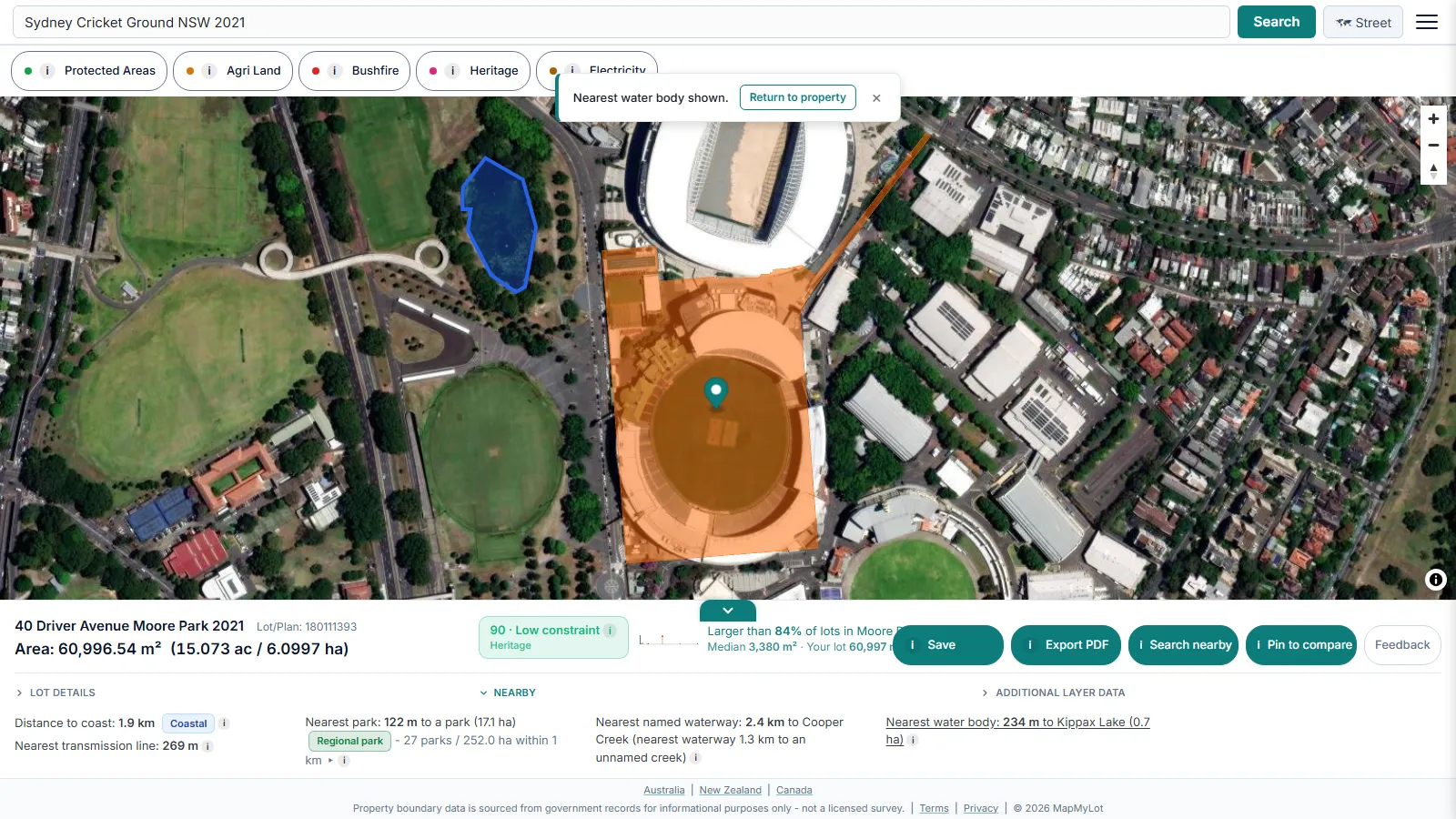
The nearest water body is identified by name where the source data has one, with its area shown as a size band:
- Pond - under 1 hectare (10,000 m2). A small body of standing water, often a stormwater basin or a farm dam.
- Small lake - 1 to under 10 hectares. Large enough to be a genuine local landmark and support recreation.
- Lake - 10 hectares or more. A substantial body of water, often named and mapped as a significant local feature.
A stormwater pond a short walk away is a very different amenity from a genuine lake the same distance away, and the size band makes that distinction visible at a glance instead of hiding it behind a single nearest-water-body number. These bands are MapMyLot's own classification for interpreting the area figure, not an official hydrological standard.
Where the data comes from
Water body name, distance, and area are drawn from OpenStreetMap contributors' mapped water polygons, community-mapped and continuously updated rather than a single static government survey. The same dataset also backs MapMyLot's waterway distance signal, so a property can show both a nearest river or creek and a separate nearest lake or pond reading when both exist nearby.
Coverage
Water body distance is currently live where this data has been loaded:
- Australia: Queensland, New South Wales, Victoria, Tasmania, and the ACT
- New Zealand
- UK: England, Wales, and Scotland
- Canada: British Columbia
Not yet covered:
- Canada: Manitoba, New Brunswick, and Yukon
A property with no water body reading may genuinely have no nearby mapped lake or pond, or it may sit somewhere this data has not been loaded yet - MapMyLot does not distinguish the two from the data alone, and never shows an absent reading as "no water nearby".
Related proximity checks
Water body distance is one of six proximity signals MapMyLot calculates automatically from a single address search, alongside a separate reading for the nearest named river, creek, or canal. See the proximity overview, check a property's distance to the nearest waterway, or its distance to the coast.
Before you rely on it
A water body distance from MapMyLot is a starting point for research, never a substitute for a council flood certificate, a hydrology report, or a licensed survey. Anything material to a purchase, build, or insurance decision should always be confirmed with the relevant council or a qualified professional.
Check a property's distance to a lake or water body
Check an address freeMapped in 8 jurisdictions. See the coverage list below.
Frequently asked questions
What do the water body size bands mean?
If MapMyLot shows no water body reading, does that mean the property is far from any lake or pond?
Is the distance a walking route to the water's edge?
Is my area included?
Water body distance is currently live in:
- Australia: Queensland, New South Wales, Victoria, Tasmania, and the ACT
- New Zealand
- UK: England, Wales, and Scotland
- Canada: British Columbia
Not yet covered:
- Canada: Manitoba, New Brunswick, and Yukon